The picture shows the logo and the words National Park Berchtesgaden next to the small Bavarian coat of arms
  • Home
  • Nature
      • National Park
      • » Goals
      • » Zonation
      • » History
      • » Management
      • » Regulations
      • Facts
      • » Past and present
      • » Habitats
      • » Geology
      • » Flora
      • » Fauna
      • » Climate
      • Awards
      • » IUCN
      • » Europadiplom
      • » EMAS
      • » UN-Dekade
      • » Environmental education
      • » Accessibility
  • Adventure
      • Rules & Notes
      • » Safety in the high mountains
      • » Accessibility of the paths
      • » Mountain huts & pastures
      • » Behaviour rules
      • » Climbing concept
      • » Paraglider
      • Tips for on the go
      • » Barrier free
      • » Hike
      • » Bike
      • » Winter tours
      • » Outside to the toilet
      • Events
      • » Hiking program
  • Education
      • For groups
      • » General information
      • » Nursery school and elementary schools
      • » Secondary schools
      • » Adults
      • » Guided tours through the exhibition
      • Partner schools
      • » About the project
      • » Events & school projects
      • » Participating schools
      • » Newsletter
      • » Alpine School
      • » Material
  • Research
      • Projects
      • » Ongoing
      • » Finished
      • Data
      • » Working group
      • » Basic data
      • Monitoring
      • » Golden eagle
      • » Bearded vulture
      • » Climate
      • » Spring
      • » Biodiversity
      • » Forest Intensive Plot
      • Cooperations
      • » TU München
      • » Climate
      • » Ecosystems
      • » Application
  • Infopoints
      • Haus der Berge
      • » Information center
      • » Temporary exhibitions
      • » Education Centre
      • » Outdoor area
      • » Gastronomy
      • National Park
      • » Hintersee
      • » Wimbachbrücke
      • » Jenner mountain station
      • » St. Bartholomä
      • » Kühroint
      • » Engert-Holzstube
      • Other facilities
      • » Carrion ecology
      • » Observation Point
      • » Deer Feeding
      • » Suspension bridge
      • » Mobile stands
      • » Info2go
      • » Actionbound
  • Service
      • About us
      • » Contact
      • » Organization chart
      • » Contact Person
      • » Offices
      • » Cooperations
      • Getting there
      • » On foot
      • » By bus & train
      • » By car
      • Partner
      • » Partner initiative
      • » National Park Partner
      • » Biosphere Region
      • » More service links
      • Publications
      • » Programs
      • » Research reports
      • » Peer reviewed
      • Press
      • » Filming permits
      • » Press releases
      • » Press Photos
      • Media library
      • » Webcams
      • » Photos
      • » Videos
      • » App
      • General
      • » Imprint
      • » Accessibility
      • » Sign language
      • » Visual aid
      • » Font size
      • » Color contrast
      • » Contact
      • » Sitemap
      • » Netiquette
      • » FAQ
  • Startseite >> 
  • English >> 
  • Infopoints >> 
  • Facilities >> 
  • Suspension Bridge

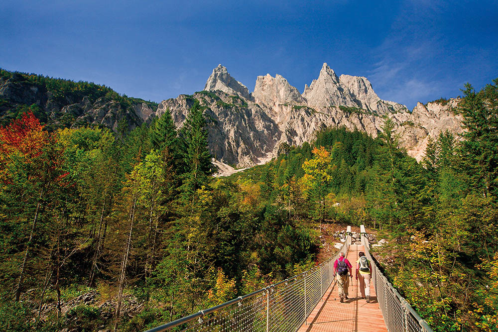
Suspension bridge over the Klausbach

National Park Facilities Suspension Bridge


Quiet location »my ass«!

Everything is in motion. Every little stone that the Klausbach stream moves downstream is a tiny part of a permanent process of change that is underway throughout the Alps. Erosion, heavy rainfall, rockfalls and ice blasting permanently change our mountains.

One night in September 1999, with a loud roar, around 250,000 m³ of rock broke off from the Kleiner Mühlsturzhorn in the summit area and fell into the valley. A huge cloud of dust settled on the trees and gave the valley an almost wintry appearance. The then wooden bridge over the Klausbach, the road and parts of the path were buried under tons of debris and the Klausbach was also forced to dig a river bed through the rock masses. The effects of the huge rockfall on the vegetation and the structure of the valley can still be seen today.

The new suspension bridge has been in place at this location since 2010. With a length of almost 55 meters and a height of a good 11 meters, it spans the watercourse and connects the two banks. The new bridge has already survived several minor rockfalls undamaged.


Did you know?

The suspension bridge over the Klausbach is accessible barrier-free, just before the bridge is a short, steeper piece to overcome. The AlmErlebnisBus stops directly at the suspension bridge during the summer months!

Info points

Haus der Berge

  • Information Center
  • Temporary exhibitions
  • Education Center
  • Outdoor area
  • Gastronomy

National Park Information Points

  • Hintersee
  • Wimbachbrücke
  • Jenner Mountain Station
  • St. Bartholomä
  • Kühroint
  • Engert-Holzstube

Other facilities

  • Carrion ecology
  • Observation points
  • Red deer feeding
  • Suspension bridge
  • Mobile stands
  • Info2go
  • Actionbound

Information Center

  • Logo Haus der Berge

  • +49 8652 979060-0
  • hausderberge@npv-bgd.bayern.de
  • Hanielstraße 7
    83471 Berchtesgaden

National Park Administration


  • +49 8652 9686-0
  • poststelle@npv-bgd.bayern.de
  • Doktorberg 6
    83471 Berchtesgaden

Service

  • FAQ

Awards

  • Logo IUCN II Logo Europadiplom Logo EMAS Logo UN-Dekade Logo Environmental Education Bavaria Logo Barrier-free Bavaria


Social Media

Visit us at Social Media


Deutsche Version

  • Deutschlands einziger Alpen-Nationalpark

Berchtesgaden National Park - Privacy | Imprint | Sitemap | Contact