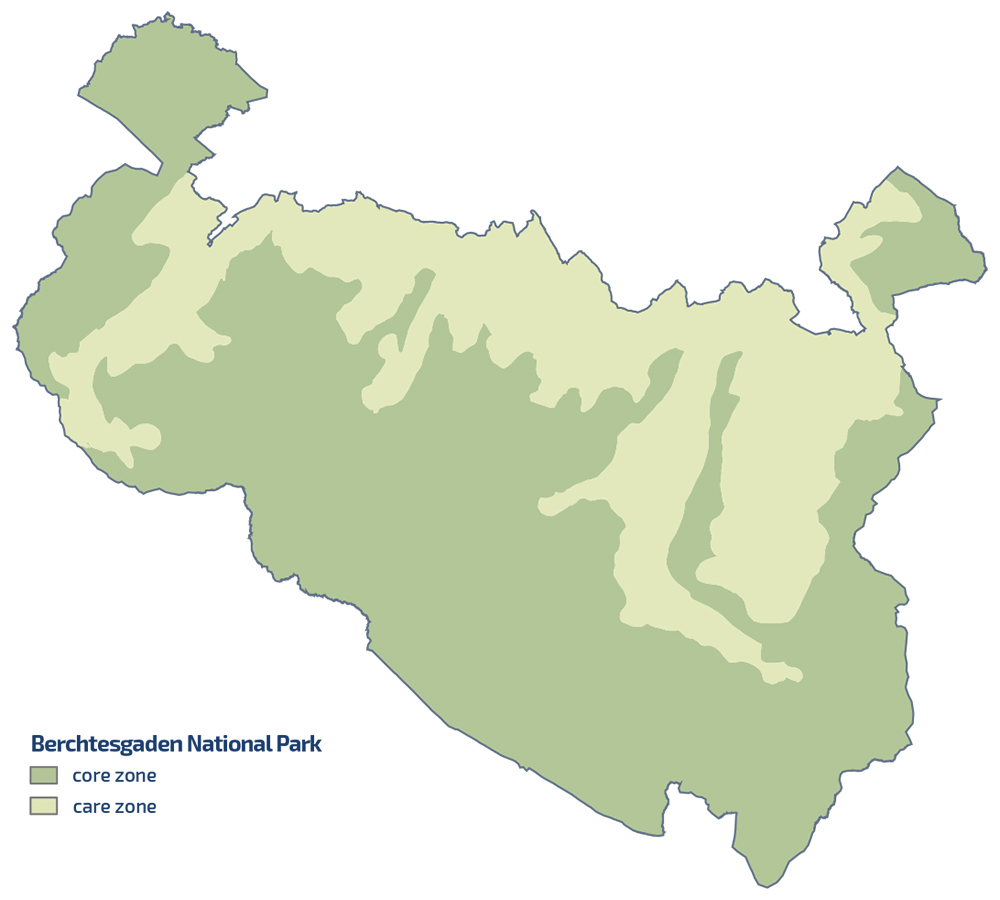
The picture shows the logo and the words National Park Berchtesgaden next to the small Bavarian coat of arms
  • Home
  • Nature
      • National Park
      • » Goals
      • » Zonation
      • » History
      • » Management
      • » Regulations
      • Facts
      • » Past and present
      • » Habitats
      • » Geology
      • » Flora
      • » Fauna
      • » Climate
      • Awards
      • » IUCN
      • » Europadiplom
      • » EMAS
      • » UN-Dekade
      • » Environmental education
      • » Accessibility
  • Adventure
      • Rules & Notes
      • » Safety in the high mountains
      • » Accessibility of the paths
      • » Mountain huts & pastures
      • » Behaviour rules
      • » Climbing concept
      • » Paraglider
      • Tips for on the go
      • » Barrier free
      • » Hike
      • » Bike
      • » Winter tours
      • » Outside to the toilet
      • Events
      • » Hiking program
  • Education
      • For groups
      • » General information
      • » Nursery school and elementary schools
      • » Secondary schools
      • » Adults
      • » Guided tours through the exhibition
      • Partner schools
      • » About the project
      • » Events & school projects
      • » Participating schools
      • » Newsletter
      • » Alpine School
      • » Material
  • Research
      • Projects
      • » Ongoing
      • » Finished
      • Data
      • » Working group
      • » Basic data
      • Monitoring
      • » Golden eagle
      • » Bearded vulture
      • » Climate
      • » Spring
      • » Biodiversity
      • » Forest Intensive Plot
      • Cooperations
      • » TU München
      • » Climate
      • » Ecosystems
      • » Application
  • Infopoints
      • Haus der Berge
      • » Information center
      • » Temporary exhibitions
      • » Education Centre
      • » Outdoor area
      • » Gastronomy
      • National Park
      • » Hintersee
      • » Wimbachbrücke
      • » Jenner mountain station
      • » St. Bartholomä
      • » Kühroint
      • » Engert-Holzstube
      • Other facilities
      • » Carrion ecology
      • » Observation Point
      • » Deer Feeding
      • » Suspension bridge
      • » Mobile stands
      • » Info2go
      • » Actionbound
  • Service
      • About us
      • » Contact
      • » Organization chart
      • » Contact Person
      • » Offices
      • » Cooperations
      • Getting there
      • » On foot
      • » By bus & train
      • » By car
      • Partner
      • » Partner initiative
      • » National Park Partner
      • » Biosphere Region
      • » More service links
      • Publications
      • » Programs
      • » Research reports
      • » Peer reviewed
      • Press
      • » Filming permits
      • » Press releases
      • » Press Photos
      • Media library
      • » Webcams
      • » Photos
      • » Videos
      • » App
      • General
      • » Imprint
      • » Accessibility
      • » Sign language
      • » Visual aid
      • » Font size
      • » Color contrast
      • » Contact
      • » Sitemap
      • » Netiquette
      • » FAQ
  • Startseite >> 
  • English >> 
  • Nature >> 
  • National Park >> 
  • Zonation

Zoning

A challenging task of the national park is to reconcile the different demands with the protection of nature. This ambitious goal cannot usually be implemented at the same time and not always in the same areas. The national park was therefore spatially divided into two zones: the core zone and the buffer zone.


Core zone: 75% of the total area

The largest part of the national park - namely three quarters, i.e. 75% - takes up the core zone. It is the heart of the national park. Here the protection of nature in its natural processes has priority, according to the motto: »Let nature be nature«. The only "uses" here are the experience of nature and the maintenance of the necessary infrastructure - all of course in line with the protection goal.


Maintenance zone: 25% of the total area

Traditional uses take place in the maintenance zone of the national park, for example shipping and fishing on Königssee or alpine farming. Alms as a valuable cultural landscape with great biodiversity can only be preserved if they are managed sustainably - as in the Berchtesgaden National Park.

In the buffer zone of the protected area there are also large areas of forest that have been used intensively for centuries as saline forests. In addition, excessive numbers of game from the days of court hunting made natural regeneration more difficult. The historical use of these forests as a fuel source for salt boiling did not follow sustainable principles at the time. The task of the national park today is to bring these forests into a state from which they can develop into healthy mixed mountain forests again.

In the buffer zone, the national park borders on its surroundings. Bark beetle management takes place at this interface. Tourist use of the national park also takes place primarily in the buffer zone.


Zoning of the Berchtesgaden National Park

Further information:

  • Goals
  • Zoniation
  • History
  • Management
  • Regulations

Nature

National Park

  • Goals
  • Zonation
  • History
  • Management
  • Regulations

Facts

  • Past and present
  • Habitats
  • Geology
  • Flora
  • Fauna
  • Climate

Awards

  • IUCN
  • Europadiplom
  • EMAS
  • UN-Dekade
  • Environmental education seal of quality
  • Accessibility

Information Center

  • Logo Haus der Berge

  • +49 8652 979060-0
  • hausderberge@npv-bgd.bayern.de
  • Hanielstraße 7
    83471 Berchtesgaden

National Park Administration


  • +49 8652 9686-0
  • poststelle@npv-bgd.bayern.de
  • Doktorberg 6
    83471 Berchtesgaden

Service

  • FAQ

Awards

  • Logo IUCN II Logo Europadiplom Logo EMAS Logo UN-Dekade Logo Environmental Education Bavaria Logo Barrier-free Bavaria


Social Media

Visit us at Social Media


Deutsche Version

  • Deutschlands einziger Alpen-Nationalpark

Berchtesgaden National Park - Privacy | Imprint | Sitemap | Contact