The picture shows the logo and the words National Park Berchtesgaden next to the small Bavarian coat of arms
  • Home
  • Nature
      • National Park
      • » Goals
      • » Zonation
      • » History
      • » Management
      • » Regulations
      • Facts
      • » Past and present
      • » Habitats
      • » Geology
      • » Flora
      • » Fauna
      • » Climate
      • Awards
      • » IUCN
      • » Europadiplom
      • » EMAS
      • » UN-Dekade
      • » Environmental education
      • » Accessibility
  • Adventure
      • Rules & Notes
      • » Safety in the high mountains
      • » Accessibility of the paths
      • » Mountain huts & pastures
      • » Behaviour rules
      • » Climbing concept
      • » Paraglider
      • Tips for on the go
      • » Barrier free
      • » Hike
      • » Bike
      • » Winter tours
      • » Outside to the toilet
      • Events
      • » Hiking program
  • Education
      • For groups
      • » General information
      • » Nursery school and elementary schools
      • » Secondary schools
      • » Adults
      • » Guided tours through the exhibition
      • Partner schools
      • » About the project
      • » Events & school projects
      • » Participating schools
      • » Newsletter
      • » Alpine School
      • » Material
  • Research
      • Projects
      • » Ongoing
      • » Finished
      • Data
      • » Working group
      • » Basic data
      • Monitoring
      • » Golden eagle
      • » Bearded vulture
      • » Climate
      • » Spring
      • » Biodiversity
      • » Forest Intensive Plot
      • Cooperations
      • » TU München
      • » Climate
      • » Ecosystems
      • » Application
  • Infopoints
      • Haus der Berge
      • » Information center
      • » Temporary exhibitions
      • » Education Centre
      • » Outdoor area
      • » Gastronomy
      • National Park
      • » Hintersee
      • » Wimbachbrücke
      • » Jenner mountain station
      • » St. Bartholomä
      • » Kühroint
      • » Engert-Holzstube
      • Other facilities
      • » Carrion ecology
      • » Observation Point
      • » Deer Feeding
      • » Suspension bridge
      • » Mobile stands
      • » Info2go
      • » Actionbound
  • Service
      • About us
      • » Contact
      • » Organization chart
      • » Contact Person
      • » Offices
      • » Cooperations
      • Getting there
      • » On foot
      • » By bus & train
      • » By car
      • Partner
      • » Partner initiative
      • » National Park Partner
      • » Biosphere Region
      • » More service links
      • Publications
      • » Programs
      • » Research reports
      • » Peer reviewed
      • Press
      • » Filming permits
      • » Press releases
      • » Press Photos
      • Media library
      • » Webcams
      • » Photos
      • » Videos
      • » App
      • General
      • » Imprint
      • » Accessibility
      • » Sign language
      • » Visual aid
      • » Font size
      • » Color contrast
      • » Contact
      • » Sitemap
      • » Netiquette
      • » FAQ
  • Startseite >> 
  • English >> 
  • Service >> 
  • Media >> 
  • App

The app Berchtesgaden National Park with 3D maps - only in German

The app Berchtesgaden National Park with 3D maps - only in German
Nationalpark App Berchtesgaden


Designed for iPhone® and Android®


The completely newly revised app for the Berchtesgaden National Park - Germany's only Alpine National Park - offers the 1.6 million annual visitors unique 3D maps, many visitor tips, tours, mountain huts and alpine pastures, a virtual panorama, as well as a tracking tool with which visitors can record their tours.

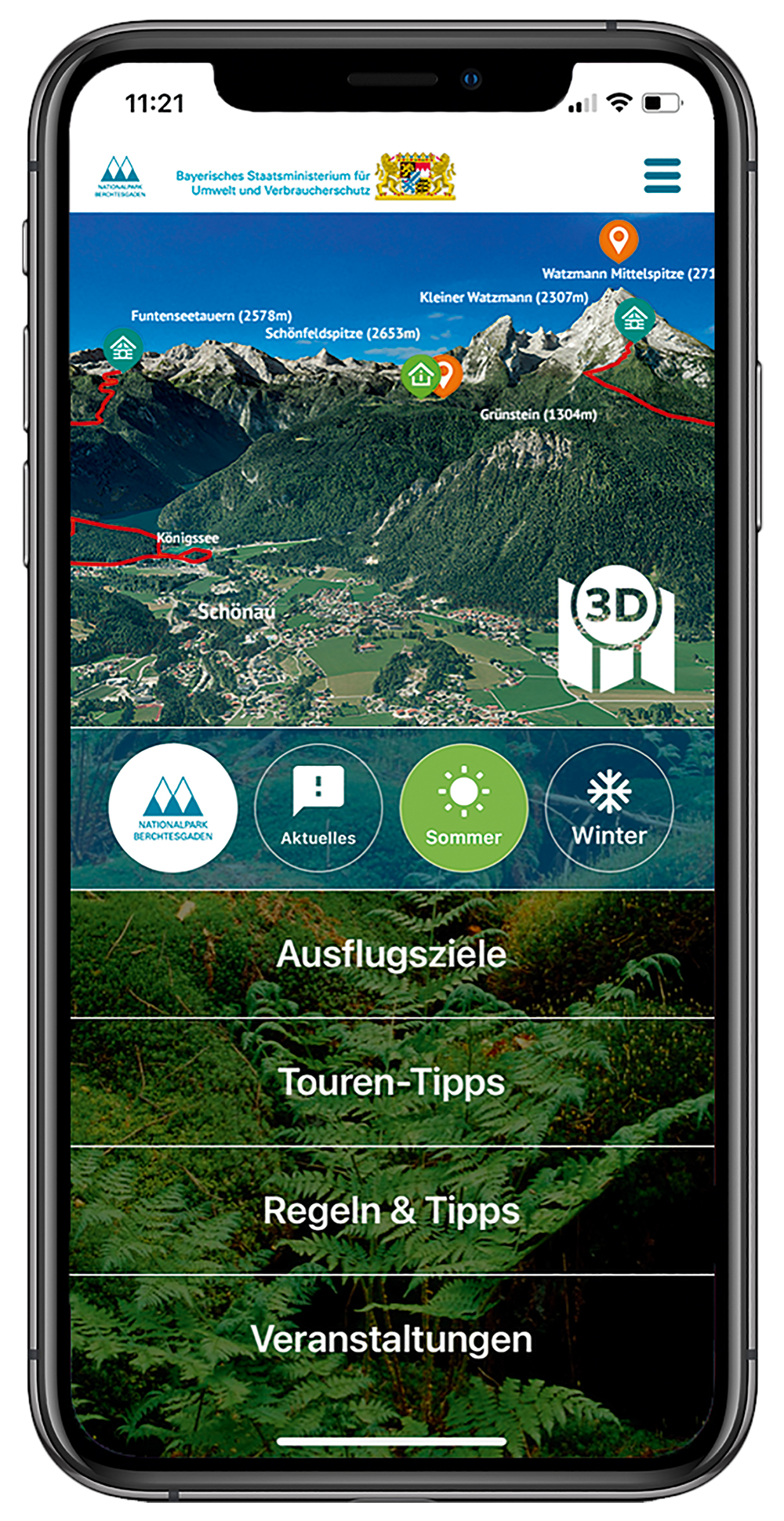
With the help of the 3-dimensional national park map, visitors see absolutely true-to-life landscapes and can orient themselves much better. 260 km of trails, tours and alpine climbs are displayed as they really are. All important geographical information is incorporated into the map. With an exact georeferencing can be checked at any time their own position. Switching between 3D map, topographic map and aerial view is possible. A great feature for a virtual reality tour experience is the "Virtual Panorama": Here, a 360° panorama can be viewed from any location, enriched with additional information such as mountain names and altitudes or points of interest such as restaurants!

The tracking tool, with which the visitor can record his tours, shows on the way point-exactly the own position, the covered way, the duration of the tour and current altitude meters. The tracking function thus facilitates orientation in the national park.

The app can be used in offline mode.

More information:

  • Webcam from Berchtesgaden National Park
  • Photos for free use
  • Latest videos from the National Park
  • National Park App in 3D

Service

About us

  • Contact
  • Organization chart
  • Contact Person
  • Offices
  • Cooperations

Partner

  • Partner initiative
  • Partner of the national park
  • Biosphere region Berchtesgadener Land
  • More service links

Getting there

  • on foot
  • by bus & train
  • by car

Press

  • Filming permits
  • Press releases
  • Press photos

Publications

  • Programs
  • Research reports
  • Peer reviewed

Media library

  • Webcams
  • Photos
  • Videos
  • App

Information Center

  • Logo Haus der Berge

  • +49 8652 979060-0
  • hausderberge@npv-bgd.bayern.de
  • Hanielstraße 7
    83471 Berchtesgaden

National Park Administration


  • +49 8652 9686-0
  • poststelle@npv-bgd.bayern.de
  • Doktorberg 6
    83471 Berchtesgaden

Service

  • FAQ

Awards

  • Logo IUCN II Logo Europadiplom Logo EMAS Logo UN-Dekade Logo Environmental Education Bavaria Logo Barrier-free Bavaria


Social Media

Visit us at Social Media


Deutsche Version

  • Deutschlands einziger Alpen-Nationalpark

Berchtesgaden National Park - Privacy | Imprint | Sitemap | Contact